The Gearhart Mountain Wilderness is a strikingly beautiful and relatively isolated area. Located about 20 miles northeast of Bly, Oregon it's quite a drive from most major cities in Oregon. This makes it all the better, my girlfriend and I spent nearly three days in the Wilderness and didn't see anyone else. The road to the southern trailhead passes by the Mitchell Monument, which is the only location in the lower 48 states that Americans died from a Japanese attack during World War Two.
 |
| The Mitchell Monument |
 |
| Ponderosa Pine that is still scared from the Japanese bomb attack |
The namesake of the wilderness lends it's name to the main trail through the wilderness. The Gearhart Trail runs for 13.5 miles from south to north. We started out at the Lookout or southern trailhead, it's at 6,300 feet so access is likely limited to July-October. The trail starts out with a gentle climb to the Palisades, which is a ten acre site of seemingly random rock outcroppings.
 |
| The Palisades |
Because of our relatively late start we decided to hike the half mile and find somewhere to camp in the Palisades. We found an awesome spot under a massive Ponderosa Pine towards the north end of the rocks.
 |
| Campsite in the Palisades |
 |
| Sunset over Gearhart Wilderness |
There is no water before or near the Palisades and we weren't all that sure where the next water source would be, so we carried out six liters of water from the trailhead. In the morning we set out for Blue Lake on the north end of Gearhart Wilderness.
 |
| Rocky outcrop near The Dome |
As the trail passes The Dome, you come to a creek twice. First it will be a slight and very visible trail down to the stream, after one more long switchback you will cross the creek. I suggest getting water from the second access point, it was much colder and closer to the source. As the trail ascends Lodgepole Pine begins to dominate the forest.
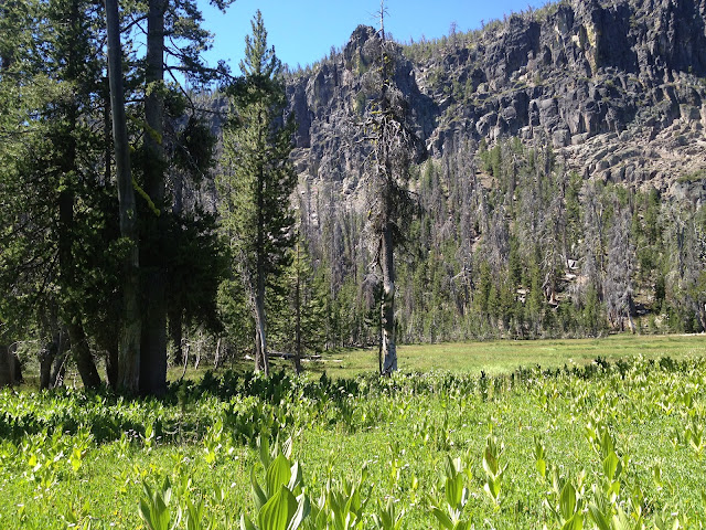
Knowing that the temperature back home in the Willamette Valley were going to be around 100 I figured it would be insanely hot here too. I was wrong, it was always pleasant in the shade, the sun on the open slopes of beetle killed Lodgpole was oppressive, but tolerable. After climbing to one saddle the trail drops slightly and passes near a large meadow, directly below a large rock face.
After the awesome meadow you begin the final push to the saddle near the Gearhart Mountain. The trail is somewhat shaded by the few Lodgepole Pines that have survived.
 |
| Sparse shade before the summit |
 |
| The trail as you reach the summit near Gearhart Mountain |
We decided to take a break on top and take in the views and eat a snack.
 |
| View southeast from the saddle below Gearhart Mountain |
 |
| Gearhart Mountain |
The section of trail down to Blue Lake was fairly dusty and hot. I would suggest getting an early start if you plan to climb up this. It doesn't really switchback, it just follows a ridge down to the Gearhart Marsh, before cutting northeast to the much more pleasant environs of Blue Lake.
 |
| The trail can be hard to follow just before Blue Lake |
 |
| Interesting Lodgepole growth |
After nearly running down to the lake to get a drink, my girlfriend spotted some wild onions growing near the shore of Blue Lake. After eating a few and cooling down we set out to find a campsite near Blue Lake.
 |
| Blue Lake |
 |
| Campsite on the southwest side of Blue Lake |
After hiking down to the north trailhead we decided to make a loop out of the hike and with the help of my GPS we figured out that we could follow Forest Road( FR) 3342 to a junction with FR 212 and then follow FR 212 back to the trailhead. I suggest this route if you don't mind about 4 miles of walking on a current gravel road, we wear Fivefingers, so it was fairly unpleasant. Once you hit FR 212 the surface is mostly natural surface, so it wasn't bad on our feet. FR 212 was definitely a nice walk, it passes through a few meadows, an old campground along Dairy Creek and past some impressive old growth.
 |
| North trailhead |
 |
| Meadow along FR 212 |
 |
| Crossing of Dairy Creek along FR 212 |
 |
| Old growth Pines and Fir |
If you have a few days and need some solitude and high desert beauty, check out the Gearhart Mountain Wilderness.
Directions from Bly: Follow Highway 140 1.4 miles east turn left on Campbell Road, in .5 mile turn right onto FR 34, in 15 miles turn left on FR 012, there is a sign for the wilderness, follow until the road ends at trailhead.
Hike Distance: 26 miles
Hike Type: Loop
Elevation Gain: Approximately 2000 feet
Highest Point: Saddle below Gearhart Mountain 8,120
Usage: Light
Difficulty: 3 out of 5
 |
| Thunderstorm rolling in |


Comments
Post a Comment