McQuade Creek Trail: Spring Gateway to the Middle Santiam Wilderness

The Middle Santiam Wilderness is an incredible place. Massive Douglas-fir, western hemlock and western redcedar line much of McQuade Creek Trail and the Chimney Peak Trail.
After calling the Sweet Home Ranger Station and finding out that the trail head on the south side of the Wilderness would likely be closed until July, because of snow, I decided to find another route in. The lady I was talking with was pretty knowledgeable and let me know that Forest Road( FR) 1142 was open, but a massive rock blocked the road one mile from the trail head. That wasn't much of a deterrent an extra two miles round trip wouldn't hurt.
 | ||||
| The rock blocking FR 1142 |
The McQuade Creek Trail starts out with 2 fairly rapid creek crossings, both of them being about calf high on me( I'm about 5'6) as of June 2, 2012. The trail then begins to slowly climb through a relatively recent clear-cut, which gives you a pretty awesome view of the valley below.

 | |||||||||
| Campsite for day number 1, small stream runs behind it. |
Our campsite for the first night wasn't good, and I wouldn't suggest it. We were planning on hitting the remains of McQuade Creek shelter, but because of work we left town much later than anticipated. In the absolutely pouring rain we quickly put our tent up jumped it. The rain never stopped all night, I was some what concerned we would end up in a pond, but it never happened.
Thankfully as I awoke the rain stopped long enough for us to pack our completely soaked tent. As we started to walk again we hit the part of the trail that is more like an obstacle course than a hiking trail. The Forest Service hasn't really maintained the McQuade Creek Trail in about 3 years. When I found this out I brought some hand trimmers to take down some of the smaller plants growing over and in the trail.
 |
| Tasty ramen with bacon for dinner. |
 |
| 2 of the many large trees across the trail |
 |
| Some of the worst |
About a mile before the McQuade Creek Shelter the trail could be hard to follow if there are still snow patches, but if you have a topo map, and have a general idea where you are going the trail stands out. Also look for the cut Devil's Club, it's pretty dense in the open areas, so the trail should stand out. Soon you will pass what remains of the McQuade Creek Shelter. There is room for one or two tents near the site. There is also part of a shovel if you want to make the site better.
There is a small campsite atop the ridge at the Chimney Peak trail junction. It's flat, but it lacks water and was pretty windy while we were up there. This is also were you officially enter the Middle Santiam Wilderness!


We weren't sure where our camp the second night would be, the farthest we wanted to walk was Donaca Lake. Any awesome site before that would be good enough though.After descending about 3 miles from the wilderness entry sign we came across what we both had pictured for camp.

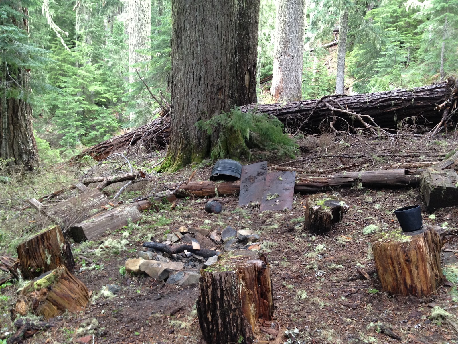
It was flat, next to a beautiful creek and it even had a fire pit with some rustic benches. It really reminded me of how lucky I was to camp near spots like this many nights along the Pacific Crest Trail.

Thankfully the sun had started to peak out and when we reached camp the sun was shining on a spot were we could dry out our tent. Before we got in for the night it was completely dry, which was surprising! Hiking the fairly short distance we did, it gave us some time to explore around camp, which was a nice change of pace. We found a pretty awesome looking set of trees!

 |
| Small campsite near the remains of the McQuade Creek Shelter |
 |
| Fire pit at the McQuade Creek Shelter |


 | |
| We left a few small pieces of wood next to the fallen tree for the next campers |


Somehow we didn't get anymore rain the rest of the trip. After breakfast we sadly had to packed up and headed back the way we came. Donaca Lake and the Shed Shelter will be saved for another trip to the Middle Santiam Wilderness. I definitely can't wait for my next trip here!
Directions From Sweet Home: Highway 20 East for about 4 miles, turn left onto Quratzville Road( FR 11). Follow FR 11 for approximately 28 miles, watch for FR 1142. Follow FR 1142 until the large boulder. The trail head is about a mile from the boulder on the left, there are signs.
Hike Distance: Approximately 16 miles
Hike Type: Out and Back
Elevation Gain/ Loss: Approximately 5,000 feet
Highest Point: Wilderness Boundary Sign 4,748 feet
Usage: Light
Difficulty: 4 out of 5 only because of some of the massive trees covering the trail, otherwise it would be a 2 of 5.


I was doing a Google search for info on backpacking in the Middle Santiam Wilderness and guess who's site I stumbled onto? haha! Nice write-up!
ReplyDeleteAwesome! That's why I started writing it... I always hated Googling a place and not finding pictures. The FS has now logged out McQuade Creek trail and the large rock is gone. Also, I'd be willin to bet it's now snow-free.
ReplyDeleteHi John,
ReplyDeleteGreat site you have here-one of the best I've found for detailed information on hikes around Oregon!
On the off-chance you frequently monitor your blog comments and don't mind doling out advice: my husband and I have a free weekend and want to do some backpacking. We'd like to get started Friday night. We're based in Albany, and probably won't be able to head out until after work, 5 p.m. or so. We're looking for a hike that starts somewhere reasonably close to us, and where we can hike in to a camping spot before it gets dark. The next day, Saturday, we could definitely continue further, but then we'll need to be able to get the entire way back to our car and return home on Sunday.
Any thoughts on a hike that might work for us?
Thank you very much! I've often felt that many sites lack information that I'm always wanting, is there any information that you would like to see included about hikes?
ReplyDeleteSorry I didn't get back to you sooner, but this hike is definitely one of my favorite short weekend backpacking trips. Also another hike that is farther away but could be done in similar fashion is Dillon Lake in Three Sisters Wilderness.
http://cascadialiving.blogspot.com/2012/07/dillon-lake-one-night-backpacking-in.html
Happy trails,
John
wondering if this could be done as a day trip to just go up and down the McQuade trail. just bought my first car and looking to hit trails in areas I haven't had the chance to as of yet. thank you for the write up! also hope you are monitoring this email !!!
ReplyDelete